OFFICIAL MARION ISLAND (ZS8MI) RADIO AMATEUR PAGE
HartRAO
(NRF)/SANAP (DEAT)
|
|
HartRAO DXpedition
|
|
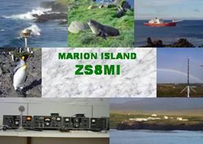
ZS8MI
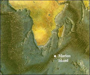
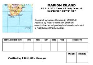
Marion Island
(Prince Edward Islands)
AF 021
ITU Zone 57 / CQ Zone 38
460 30 - 470
00 S
370 30 - 380
05 E
|
Department of
Environmental Affairs and Tourism (DEAT)
South African National
Antarctic Programme (SANAP)
HartRAO
Space Geodesy Programme
MARION ISLAND RELATED LINKS
QSL information / Am I in the Log?
Learn more about Marion Island
Our Operations
Our Equipment
HF
Propagation from Marion Island
DXpedition photographs
The Dxpedition
Two staff members of the Hartebeesthoek Radio
Astronomy Observatory (HartRAO) Space Geodesy Programme, Ludwig Combrinck
and Pieter Stronkhorst, will visit Marion Island during April 2004. Backup to update log files and images
taken during the voyage and island visit will be provided by Attie. The SA Agulhas (nice photo)
will depart from Cape Town on the 1st of April 2004 and will return on the 7th
of May. We expect to reach the
island within about four to five days.
During the ocean voyage, maritime mobile operation should be
possible from the vessel.
Depending on offloading of equipment and other work load, IOTA
operations will commence on the 7th of April until about the
end of the month. This is primarily a scientific trip, so DXpedition
activities will be accommodated as time permits.
|

|

|

|

|
|
Ludwig
Combrinck
ZS6WLC
|
Pieter
Stronkhorst
ZR6PSR
|
Attie Combrink
(will be a HAM
soon!)
|
Bushy Roode
ZS6M (ex ZS6YQ)
|
Latest News
12th March – Attie and Ludwig traveled to Cape Town to ensure that the equipment
arrived safely by truck from Johannesburg (about 1500 km). Fortunately all was in tact, but
evidently the crate took a few beatings.
So we can report that all scientific equipment and DX equipment
are safe in a warehouse (in an undisclosed location!) of the Department
of Environmental Affairs and Tourism which provides logistics for the
SANAP program.
24 March
– The
call-sign ZS8MI (Marion Island) has officially been
allocated to HartRAO, who will administer the call-sign on behalf of
DEAT. We will therefore be able to use this web site for future Marion
Island DXpeditioners, referring to past visits via links, and warning the
HAM community well in advance about future visits to the island.
28 May – Well, finally found some to
time update the webpage a bit. Net results of the DXpedition are 190 CW
and 1844 SSB contacts, 96 countries.
10 September – We have started mailing QSL cards, thank
you for waiting so patiently. We had to wait for your cards to be sent to
us first, and finally decided on how many cards to print. In the
meanwhile I had to rush off to France, Germany, Norway and Lesotho, so had very little time to
even think about amateur radio never mind updating this web page. So once
again, thank you for being patient. We received about 600 cards in total.
Those who e-mailed about not having dollars etc., don’t worry, if I
received a card from you I will mail you a card.
Some QSL feedbacks:
From Bill Leehan N5SUM, Hi Ludwig, received
the beautiful ZS8MI card. Thanks very much for #319 and for helping so
many hams with a new DXCC. 73, Bill, N5SUM
From Jim Kirk KJ5X, Many thanks Ludwig for
ZS8MI card I found in the mail box today. #325. Good Luck and many
thanks. Jim Kirk, KJ5X.
Some
images from Marion Island
(will add a separate page with many photos later)
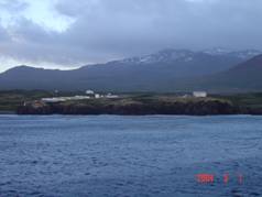 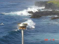
Marion base as seen from the SA Agulhas. GPS antenna installed at Transvaal
Cove
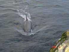
Killer whale visiting the island
Acknowledgements, credits and expressions of gratitude
We would like to thank, at the outset, and before
the onset, our wives and families who smiled when we announced we would
be away for six weeks visiting an island in the Roaring Forties. In addition, we thank the staff at
HartRAO who showed such an immense interest in the project and our
objectives, especially André van der Merwe, our resident instrument
making genius. To Fritz van der
Merwe (Geography Department, University of Pretoria) our gratitude for
lending us two Trimble dual-frequency GPS receivers and logger which will
enable us to calibrate and improve the digital elevation map of the
island. A special thanks is
appropriate to Tilo Schoene (GFZ
Potsdam) who contributed an Ashtech Z12 GPS receiver which we will
install as a permanent IGS
station. To Dave Stowers and
Oivind Ruud, (Jet Propulsion Laboratory, NASA) who has
helped us several times in the past, thanks for the PC and meteorological
unit (they make the best jelly beans in the States!). Kobus Olckers from
IMT kindly provided our HF propagation maps.
Our Schedule (and this can change anytime)
|
April 2003
|
Submit proposal to DEAT to install a tide gauge and GPS
receiver on Marion Island
|
October 2003
|
Preliminary approval of expedition
|
December 2003
|
Receive met unit and PC from JPL
|
January 2004
|
Purchase Jasco 15m crank-up mast
|
|
February 2004
|
Receive Ashtech Z12 from Germany
|
|
March 2004
|
Construct wooden crate and multi-band dipole antenna
|
|
Friday 12
March 2004
|
Book in all equipment to be placed in hold of SA Agulhas
|
|
Thursday 1
April 2004
|
Scheduled anchor aweigh from Cape Town, Quay 500
|
|
Monday 5 April
2004
|
Expected arrival at Marion Island
|
|
Sunday 2 May
2004
|
Expected departure from Marion Island
|
|
Friday 7 May
2004
|
Anchor at the Cape of Good
Hope
|
Callsigns
The official call-sign of Marion Island, ZS8MI, will be used whilst
on the island. En voyage ZS6WLC
will be maritime mobile on the 20m and 40m bands. Please do not QSL
via anybody else except ZS6M. Historically, Chris Burger (ZS6EZ) acted as QSL
manager, or rather tried to sort out the QSL problems with previous HAM
operations from Marion Island. Apparently major confusion
has existed in the past as to who is the QSL manager for ZS8MI. Chris is not the QSL manager for this
DXpedition. He is also not the QSL manager for ZS8MI. ZS8MI is
administered by HartRAO in collaboration with DEAT. Therefore please
note:
Only QSL’s to ZS6M will be
answered.
Objectives
Primary objectives of the expedition are to equip
the island with a permanent GPS station (part of the TIGA southern
Africa Research Group (TIGAsA) network), determine its exact position
(translated and rotated in the ITRF), calibrate/improve the existing
digital elevation map of the island and upgrade the French DORIS
station. The DXpedition is a
component of this visit to the island and will serve to promote awareness
of the scientific activities and environmental conservation projects on
the island.
Queries/contact
All queries
via e-mail must be directed to Ludwig
Combrinck .
|