
HartRAO Home > How to get to HartRAO
Directions from:
Note that all visits must be booked in advance.
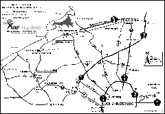
HartRAO is in the centre of this Google map. Zoom in to see more detail, or zoom out to see our location in Africa. Zooming out, Hartebeestpoort dam will be seen to the upper right, and Johannesburg to the lower right.
For those navigating by GPS, the coordinates of the carpark in front of the
HartRAO Visitor Centre are:
Latitude 25° 53' 27.1" South
Longitude 027° 41' 12.7" East.
The entrance to HartRAO/SANSA from the R400 road is 3 km East of this.
Hartebeesthoek Radio Astronomy Observatory (HartRAO)
Farm 502JQ Hartebeesthoek
Broederstroom Road R400 / T7 (off R563 towards Broederstroom)
Krugersdorp District
Krugersdorp 1739
South Africa
HartRAO is located in a tourist area near the Maropeng Visitor Centre and the Sterkfontein Caves in the Cradle of Humankind.
For information about accommodation in the area around HartRAO, see:
Magaliesburg Meander,
Magalies Info,
Gauteng Tourism Authority
Where to stay -
Gauteng.
The Space Operations Directorate of the South African National Space Agency (SANSA) is located on the hill above HartRAO and shares a common entrance from the R400 road. It used to be called the Satellite Application Centre of the CSIR. It is sometimes confused with HartRAO. The SANSA Space Operations missions comprise spacecraft tracking, telemetry and communications activities, launch support, in-orbit testing, mission control and space navigation. Satellite imagery can be obtained from them. Phone +27 12 334-5000.