Geodetic Systems
The IISGEO has in mind to facilitate all the different Space Geodesy systems available - just like it is currently done at HartRAO. A big extra will be a Lunar Laser Ranging (LLR) device.
VLBI
VLBI (Very Long Baseline Interferomity) is technique to define a reference frame and measure the orientation of the earth within that frame. Changes in the orientation of the earth have two causes: the gravetational forces of the sun and the moon and the redistribution of total angular momentum among the solid earth, ocean and the atmosphere. VLBI makes a direct measurement of the earth's orientation in space from which geoscientists then model such phenomena as atmospheric angular momentum, ocean tides and currents, and the elastic response of solid earth.
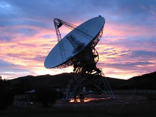 |
| Figure 1. A beautifull picture of the Radio Antenna at sunset in HartRAO. This dish is 26m in diameter. |
SLR/LLR
Satelite Laser Ranging is a technique used to determine the position of the earth and of the satellites relative to eachother. In satellite laser ranging a global network of stations measure the instantanious roundtrip time of flight of ultra short pulses of light to satellites equipped with special reflectors. This provides instantanious range measurements of millimeter level precision which can be accumulated to provide accurate orbits and a host of important science products.
With Lunar Laser Ranging we extend the SLR to be able to reach all the way to the moon. Currently there are no LLR station in the Southern Hemesphere and there are only (get the amount) in the world. LLR is a technique in which the round trip travel times of light pulses between stations on the earth and four retroreflectors on the moon are measured.
The main goal with LLR is to achieve precision to a few picoseconds, which corresponds to about one millimeter in range to the moon. Using this information, we will be able to gauge the relative acceleration of the earth and Moon toward the sun (like a modern-day Leaning Tower of Pisa experiment) in order to ascertain the free-fall properties of earth's gravitational self-energy.
GPS
Global Positioning Services (GPS) consists of a network of satellites orbiting the earth and a receiver on the ground that work together to determine the position of the receiver on the earth with a precision of a few meters. The main advantage of GPS is that you can have a great number of receivers work together to get a big picture of what is going on.